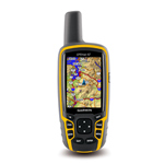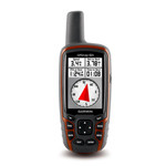
GARMIN MAP 62S GPS Mapping Handheld
GARMIN MAP 62S GPS Mapping Handheld
GPSMAP 62s features a 3-axis tilt-compensated compass, a barometric altimeter and supports Custom Maps, BirdsEye™ Satellite imagery (subscription required) and photo navigation. Rugged and waterproof, GPSMAP 62s employs a quad helix antenna for unparalleled reception, has a high-speed USB connection, a sleek new design and connects wirelessly to compatible handheld devices.
Physical & Performance:
|
| Unit dimensions, WxHxD: |
2.4″ x 6.3″ x 1.4″ (6.1 x 16.0 x 3.6 cm) |
| Display size, WxH: |
1.43″ x 2.15″ (3.6 x 5.5 cm); 2.6″ diag (6.6 cm) |
| Display resolution, WxH: |
160 x 240 pixels |
| Display type: |
transflective, 65-K color TFT |
| Weight: |
9.2 oz (260.1 g) with batteries |
| Battery: |
2 AA batteries (not included); NiMH or Lithium recommended |
| Battery life: |
20 hours |
| Waterproof: |
yes (IPX7) |
| Floats: |
no |
| High-sensitivity receiver: |
yes |
| Interface: |
high-speed USB and NMEA 0183 compatible |
Maps and Memory:
|
| Basemap: |
yes |
| Preloaded maps: |
no |
| Ability to add maps: |
yes |
| Built-in memory: |
1.7 GB |
| Accepts data cards: |
microSD™ card (not included) |
| Waypoints/favorites/locations: |
2000 |
| Routes: |
200 |
| Track log: |
10,000 points, 200 saved tracks |
Features and Benefits:
|
| Automatic routing (turn by turn routing on roads): |
yes (with optional mapping for detailed roads) |
| Electronic compass: |
yes (tilt-compensated, 3-axis) |
| Touchscreen: |
no |
| Barometric altimeter: |
yes |
| Camera: |
no |
| Geocaching-friendly: |
yes (paperless) |
| Custom maps compatible: |
yes |
| Photo navigation (navigate to geotagged photos): |
yes |
| Hunt/fish calendar: |
yes |
| Sun and moon information: |
yes |
| Tide tables: |
yes |
| Area calculation: |
yes |
| Custom POIs (ability to add additional points of interest): |
yes |
| Unit-to-unit transfer (shares data wirelessly with similar units): |
yes |
| Picture viewer: |
yes |
| Garmin Connect™ compatible (online community where you analyze, categorize and share data): |
yes |
Kata Kunci Banyak Dicari :
- Download garmin untuk gps di kota malang
- gps garmin malang
- konter garmin di malang
]]>