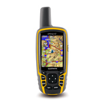
GPS Garmin MAP 62
GPS Garmin MAP 62
GPSMAP 62 features a 2.6″ sunlight-readable 65K color screen that supports BirdsEye Satellite imagery (subscription required) and Custom Maps. Rugged and waterproof, GPSMAP 62 features a quad helix antenna for unparalleled reception and sleek new design.
Physical & Performance: |
|
| Unit dimensions, WxHxD: | 2.4″ x 6.3″ x 1.4″ (6.1 x 16.0 x 3.6 cm) |
| Display size, WxH: | 1.43″ x 2.15″ (3.6 x 5.5 cm); 2.6″ diag (6.6 cm) |
| Display resolution, WxH: | 160 x 240 pixels |
| Display type: | transflective, 65-K color TFT |
| Weight: | 9.2 oz (260.1 g) with batteries |
| Battery: | 2 AA batteries (not included); NiMH or Lithium recommended |
| Battery life: | 20 hours |
| Waterproof: | yes (IPX7) |
| Floats: | no |
| High-sensitivity receiver: | yes |
| Interface: | USB and NMEA 0183 compatible |
Maps and Memory: |
|
| Basemap: | yes |
| Preloaded maps: | no |
| Ability to add maps: | yes |
| Built-in memory: | 1.7 GB |
| Accepts data cards: | no |
| Waypoints/favorites/locations: | 2000 |
| Routes: | 200 |
| Track log: | 10,000 points, 200 saved tracks |
Features and Benefits: |
|
| Automatic routing (turn by turn routing on roads): | yes (with optional mapping for detailed roads) |
| Electronic compass: | no |
| Touchscreen: | no |
| Barometric altimeter: | no |
| Camera: | no |
| Geocaching-friendly: | yes (paperless) |
| Custom maps compatible: | yes |
| Photo navigation (navigate to geotagged photos): | yes |
| Hunt/fish calendar: | yes |
| Sun and moon information: | yes |
| Tide tables: | yes |
| Area calculation: | yes |
| Custom POIs (ability to add additional points of interest): | yes |
| Unit-to-unit transfer (shares data wirelessly with similar units): | no |
| Picture viewer: | yes |
| Garmin Connect™ compatible (online community where you analyze, categorize and share data): | yes |
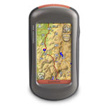
GPS Garmin Oregon 450
GPS Garmin Oregon® 450
Oregon 450 features a rugged, sunlight-readable touchscreen along with a built-in basemap with shaded relief, a high-sensitivity receiver, barometric altimeter, 3-axis electronic compass, microSD™ card slot, picture viewer and more.
Physical & Performance: |
|
| Unit dimensions, WxHxD: | 2.3″ x 4.5″ x 1.4″ (5.8 x 11.4 x 3.5 cm) |
| Display size, WxH: | 1.53″W x 2.55″H (3.8 x 6.3 cm); 3″ diag (7.6 cm) |
| Display resolution, WxH: | 240 x 400 pixels |
| Display type: | transflective color TFT touchscreen |
| Weight: | 6.8 oz (192.7 g) with batteries |
| Battery: | 2 AA batteries (not included); NiMH or Lithium recommended |
| Battery life: | 16 hours |
| Waterproof: | yes (IPX7) |
| Floats: | no |
| High-sensitivity receiver: | yes |
| Interface: | high-speed USB and NMEA 0183 compatible |
Maps and Memory: |
|
| Basemap: | yes |
| Preloaded maps: | no |
| Ability to add maps: | yes |
| Built-in memory: | 850 MB |
| Accepts data cards: | microSD™ card (not included) |
| Waypoints/favorites/locations: | 2000 |
| Routes: | 200 |
| Track log: | 10,000 points, 200 saved tracks |
Features and Benefits: |
|
| Automatic routing (turn by turn routing on roads): | yes (with optional mapping for detailed roads) |
| Electronic compass: | yes (tilt-compensated, 3-axis) |
| Touchscreen: | yes |
| Barometric altimeter: | yes |
| Camera: | no |
| Geocaching-friendly: | yes (paperless) |
| Custom maps compatible: | yes |
| Photo navigation (navigate to geotagged photos): | yes |
| Hunt/fish calendar: | yes |
| Sun and moon information: | yes |
| Tide tables: | yes |
| Area calculation: | yes |
| Custom POIs (ability to add additional points of interest): | yes |
| Unit-to-unit transfer (shares data wirelessly with similar units): | yes |
| Picture viewer: | yes |
| Garmin Connect™ compatible (online community where you analyze, categorize and share data): | yes |
Montana 650t has a vast 4″ sunlight-readable touchscreen display, giving you crystal clear enhanced colors and high-resolution images. Its easy-to-use interface means you’ll spend more time enjoying the outdoors and less time searching for information. Montana 650t is built to withstand bumps, dust, dirt, humidity and water. It’s right at home on a boat, RV or ATV.
Physical & Performance: |
|
| Unit dimensions, WxHxD: | 2.9″ x 5.7″ x 1.4″ (7.48 x 14.42 x 3.64 cm) |
| Display size, WxH: | 2″W x 3.5″H (5.06 x 8.93 cm); 4″ diag (10.2 cm) |
| Display resolution, WxH: | 272 x 480 pixels |
| Display type: | bright, transflective 65k color TFT, dual-orientation touchscreen; sunlight readable |
| Weight: | 10.2 oz (289 g) with included lithium-ion battery pack; 11.7 oz (333 g) with 3 AA batteries (not included) |
| Battery: | rechargeable lithium-ion (included) or 3 AA batteries (not included); NiMH or Lithium recommended |
| Battery life: | up to 16 hours (lithium-ion); up to 22 hours (AA batteries) |
| Waterproof: | yes (IPX7) |
| Floats: | no |
| High-sensitivity receiver: | yes |
| Interface: | high-speed USB and NMEA 0183 compatible |
Maps and Memory: |
|
| Basemap: | yes |
| Preloaded maps: | yes (topographic) |
| Ability to add maps: | yes |
| Built-in memory: | 3.5 GB |
| Accepts data cards: | microSD™ card (not included) |
| Waypoints/favorites/locations: | 4000 |
| Routes: | 200 |
| Track log: | 10,000 points, 200 saved tracks |
Features and Benefits: |
|
| Automatic routing (turn by turn routing on roads): | yes (with optional mapping for detailed roads) |
| Electronic compass: | yes (tilt-compensated, 3-axis) |
| Touchscreen: | yes |
| Barometric altimeter: | yes |
| Camera: | yes (5 megapixel with autofocus; automatic geo-tagging) |
| Geocaching-friendly: | yes (paperless) |
| Custom maps compatible: | yes |
| Photo navigation (navigate to geotagged photos): | yes |
| Hunt/fish calendar: | yes |
| Sun and moon information: | yes |
| Tide tables: | Yes (with optional Bluechart) |
| Area calculation: | yes |
| Custom POIs (ability to add additional points of interest): | yes |
| Unit-to-unit transfer (shares data wirelessly with similar units): | yes |
| Picture viewer: | yes |
| Garmin Connect™ compatible (online community where you analyze, categorize and share data): | yes
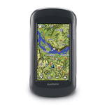 GPS Garmin Montana® 650t |